As a follow up to my story for the Guardian about open
climate data, here are Owen Boswarva's thoughts on the Environment Agency flood data releases, and his hopes for future releases. Boswarva is an open data advocate, and he sits on Defra's transparency board. He also blogs about open data for the Guardian. As only a fraction of his insights made it into the article as quotes, I have provided the full version here, as it contains a good summary of the situation as it stands, and some great links to applications that people have built using the data releases. Be sure to check out the links for some very elegant examples of what you can do with data.
#FloodHack data releases
Did FloodHack have a significant practical impact on those affected by the recent flood events? Probably not. I'm not a developer myself, and I'm generally sceptical about app-based approaches to big policy issues like flood risk.
However FloodHack was valuable in two respects:
It made the point to government that there is a strong demand for unlocking Environment Agency flood data. Often government departments have difficulty recognising the untapped potential in reuse of the data they produce. I think the high number of attendees at FloodHack, and the level of enthusiasm, convinced the Cabinet Office that there was a real appetite to make better use of flood data. That will have strengthened its hand in discussions with Defra and the EA.
The hackathon was also useful in familiarising the Tech City community with the subject of flood risk and with the datasets that the EA holds. Data discovery is an important prerequisite for building the case for open data release. There is substantial public interest in flood risk, but flood data itself is a specialised subject and not widely understood. Hands-on experience with the EA datasets has started more developers thinking about what they could do with them if they were available as open data.
On the FloodHack data and its limitations, as you probably know the EA made available several of its flood datasets as described here:
Those datasets are mainly "live" or near real-time feeds: flood alerts, river levels, etc. That was certainly the right data for the stated purposes of FloodHack, which was about coping with imminent and ongoing flood events. A number of developers made good use of the datasets during the hackathon itself, and some have continued to experiment with them subsequently.
However it's uncertain to what extent developers will be able to make future use of those datasets because the EA has only released them under an open data licence until the 15th of May. That's fine as a window for experimentation, but no open data developer can really build a business model around use of the data unless they have an assurance that it will remain open going forward.
The larger problem is that the FloodHack datasets are not the EA's core flood risk datasets. Most of the potential in open use of flood risk data is in the area you've mentioned: improving community resilience. Resilience to flood risk isn't just about reacting to flood events as they emerge; it's about understanding flood risk and preparing for it -- before the threat to the community materialises.
In the wider context of adaptation to climate change, that means raising the level of public awareness and building a critical analysis that integrates flood risk data with a range of other information (on transport infrastructure, supply chains, population and socioeconomic factors, etc.); analysis that the government is not always best positioned to do by itself.
I would certainly like to see the EA flood datasets that were released during FloodHack remain open. However I think it's even more important that we persuade the EA to release NaFRA (the national flood risk dataset used to allocate flood defence funding and also by the insurance industry) and the Flood Map (used in the local planning process), along with spatial data on flood defences.
If you want more detail on the various flood datasets held by the EA, this is my more-or-less comprehensive list:
The FloodHack release of data has given us some hints of what can be done with open flood data. This is a web app developed by Steve Peters, who works on the OpenDataCommunities platform:
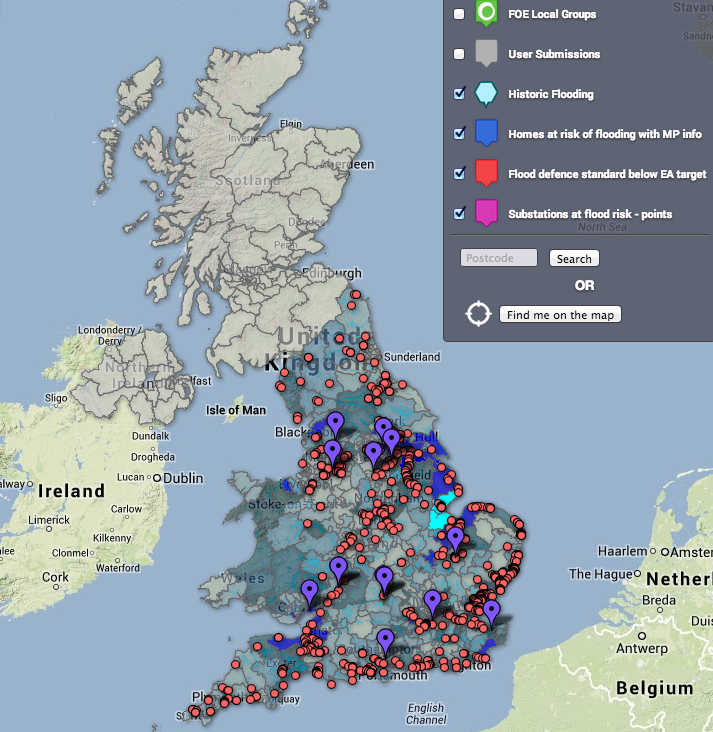
And this is a flood map produced by Friends of the Earth:
Those are both good efforts based on the open data currently available. However what I see in them is how much they could be improved by the release of more relevant flood datasets. For example the OpenDataCommunities app is trying to highlight new build properties in areas of flood risk, so would be much more accurate if it included the EA flood zone maps used by local planners. The FOE map is based on statistics provided by the Association of British Insurers; as a campaign group I'm sure FOE would much rather produce their own analysis from the underlying flood data than be dependent on the insurance industry or the government to interpret the data for them.
I do understand some of the EA's concerns about the scope for misinterpretation of flood data if it is released "into the wild". But as I said in my blog post I think this is outweighed by the potential to promote discussion and improve public understanding of the risk, iteratively.
My current understanding is that there will be some kind of further announcement from government shortly on release of flood data. (I'm a non-executive member of Defra's Transparency Board, so I've heard a few options discussed.) I am cautiously optimistic that there will be some worthwhile progress. However until there is a public announcement I have two concerns. The government may simply lose interest now that the recent bad weather (and the political fallout) drops down the public agenda. Or the EA may try to "descope" the proposition by releasing only some of their less valuable flood datasets, or by pushing the timeframe for release beyond the next Election. We will see.
-Owen Boswarva
No comments:
Post a Comment